
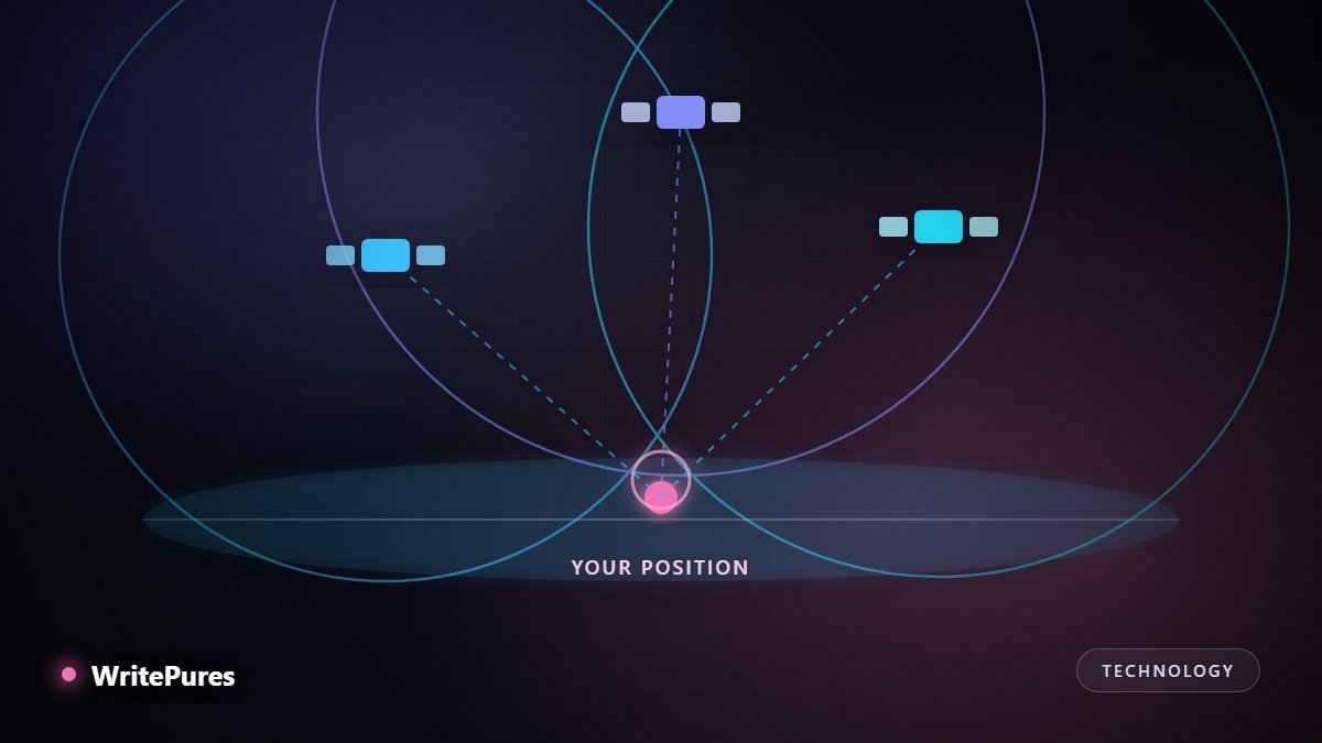
Your phone shows a blue dot within a few metres of where you are standing, using signals from objects twenty thousand kilometres overhead that have no idea you exist. The method is elegant, and it rests almost entirely on measuring time rather than distance.
It Is a Clock Problem, Not a Map Problem
Each satellite continuously broadcasts two things: where it is and the exact time it sent the message, kept by an atomic clock accurate to billionths of a second.
Your receiver notes when the signal arrived, subtracts when it was sent, and multiplies by the speed of light. That gives the distance to that satellite — and from there the geometry is straightforward.
Knowing you are a certain distance from one satellite places you on the surface of a sphere around it. A second satellite gives another sphere; two spheres intersect in a circle. A third narrows that circle to two points, one of which is implausible — out in space or deep underground — leaving one answer.
So why four?
Because that reasoning assumed your clock is perfect, and it is not. The satellites carry atomic clocks; your phone has an ordinary quartz one. Light travels about 30 centimetres per nanosecond, so a clock error of a single microsecond puts you 300 metres out.
Fitting an atomic clock into every phone is impossible, so the system solves the problem mathematically instead. With four unknowns — latitude, longitude, altitude and your clock error — you need four equations, which means four satellites. The receiver finds the clock correction that makes all four measurements agree.
A neat consequence: your phone ends up knowing the time to extraordinary precision. GPS is as much a global time service as a positioning one, and much of the world's infrastructure — telecoms, power grids, financial trading — depends on it for synchronisation rather than navigation.
Why It Fails Where It Does
| Situation | What goes wrong |
|---|---|
| Between tall buildings | Signals reflect off glass and concrete; the longer path is measured as a longer distance |
| Indoors | Signals are extremely weak and mostly blocked by roofs |
| Dense forest or canyon | Fewer satellites visible, and poor spread across the sky |
| Just switched on | No idea which satellites are overhead; must search |
| Ionospheric activity | Signals slow slightly passing through charged atmosphere |
The city problem is multipath, and it is worse than simple blockage. A reflected signal still arrives, just later, so the receiver confidently computes a distance that is too long and places you a street away. Accuracy in a dense city centre is frequently worse than in open country with a clear horizon.
Geometry matters as much as count. Four satellites spread widely across the sky give a sharp fix; four clustered in one direction give a vague one, because the spheres intersect at a shallow angle. This is why accuracy can vary while the satellite count stays the same.
How Your Phone Cheats, Productively
A pure GPS receiver can take minutes to find a position from cold. Phones are faster because they do not rely on GPS alone:
- Assisted GPS — satellite positions are downloaded over the mobile network rather than waiting to receive them from space, cutting the first fix from minutes to seconds.
- Multiple constellations — modern phones also use Galileo, GLONASS and BeiDou alongside GPS, so many more satellites are available and city performance improves substantially.
- Wi-Fi positioning — nearby network names are matched against a database of known locations. This is what usually gives you an instant, roughly correct position indoors.
- Motion sensors — the accelerometer, gyroscope and compass carry your position through a tunnel or underpass until signals return.
Because of this blending, the blue dot is usually a fusion of several sources. The circle of uncertainty around it is honest information — a wide circle means the phone is telling you it is unsure, and it is worth believing.
A note on privacy
GPS satellites broadcast only; they receive nothing and cannot detect you. Your position is computed on your own device. Everything people mean by location tracking happens afterwards, when an application transmits that calculated position somewhere — which is why reviewing which apps hold location permission matters more than anything about the satellites. Our guide to checking a phone you no longer trust covers how to audit that.
Key Takeaways
- GPS measures travel time; distance and position follow from it.
- Four satellites are needed because your phone's clock error is a fourth unknown.
- Satellite spread across the sky affects accuracy as much as how many are visible.
- Cities are hard because reflected signals are measured as longer distances.
- Satellites only broadcast — your position is calculated on your device, not reported by them.
Written by the WritePures newsroom. Spotted something that needs updating? Tell our editors.

0 Comments
Join the conversation
Replying toNo comments yet. Be the first to share your thoughts.